About Lasqueti Island
Land Use & Bylaws
- Population: Approximately 359
- Size: 6,645 hectares (16,420 acres)
- Location: 20 kilometres north of French Creek located on Vancouver Island.
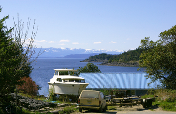
Downtown, False Bay, Lasqueti Island. PHOTO: A. Sorfleet, 2009 |
The Islands Trust – Official Community Plans
"Official Community Plans contain the broad goals and policies that help guide the preservation and development of an Island. Official Community Plans are developed with substantial input from the community, other government agencies and First Nations. Official Community Plans are adopted and administered by each Island's Local Trust Committee."
- Bylaw No. 77: Lasqueti Island Official Community Plan, 2005
(print format PDF, 160Kb)
- Bylaw No. 77 Map, Lasqueti Island, 2005
(print format PDF, 1.2Mb)
- Bylaw No. 78: Lasqueti Island Land Use,
2005 (print format PDF, 160Kb)
("A bylaw to establish regulations and requirements respecting the use of land, including the surface of water, the use, siting and size of buildings and structures, the provision of parking, landscaping and screening and the subdivision of land within the Lasqueti Island Local Trust Area.")
- Lasqueti Island Local Trust Committee
(Part of the Islands Trust – "Preserving island communities, culture and environment."
Website: islandstrust.bc.ca/ltc/la/)
Water Stewardship & Rights
- Lasqueti Island Water Allocation Plan – Ministry of Environment, Lands and Parks Vancouver Island Region. By George Brydon and Lyn Barnett, December 1992.
(print format PDF, 1.5Mb)
- Water Rights and Legislation, Water Stewardship – Ministry of Environment, Government of British Columbia
(Learn more about the many Acts, Guidelines and Safety Measures established by the Provincial Government help to ensure responsible and sustainable use of BC's water.
Website: env.gov.bc.ca/wsd/water_rights)
Maps of Lasqueti Island, BC
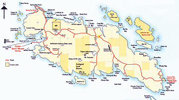
- Lasqueti Island Map (3.9Mb PDF)
(Final print size 11" x 17" (300dpi). Cropped from original source. Map courtesy of Anne Sperling, Coast Realty Group.)
- Draft Build Out Map, Lasqueti Island,
October 2008 (print format PDF, 576Kb)
- SW–Sec. 20: Location Maps (14.7Mb PDF)
(Booklet includes satellite/arial views of Lasqueti, as well as Lasqueti maps for topography, real estate, land use and the Straight of Georgia. Final print size 8.5" x 5.5".)
- Section (NTS 92-F) from Gazetteer Map of British Columbia, showing location of Lasqueti Island, Straight of Georgia, 1966 (3.1Mb PDF)
(Final print size 11" x 8.5".)

|
